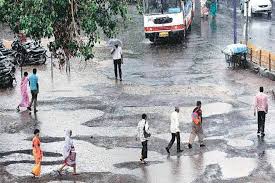
For centuries, the Kosi River has been both a blessing and a curse for the people of Bihar. Nicknamed the “Sorrow of Bihar”, this unpredictable river has brought life-giving water and fertile soil — but it has also brought some of the most devastating floods in India’s history. Year after year, entire communities in North Bihar live with the looming threat of losing their crops, livestock, homes, and sometimes their lives to the river’s shifting course and sudden overflows.
But a new ray of hope has emerged from the laboratories of IIT Roorkee, where a team of dedicated researchers has harnessed the power of Artificial Intelligence (AI) to build an innovative framework for predicting and mapping flood risks in the Kosi basin with remarkable precision. This breakthrough could transform how local governments, planners, and disaster management teams prepare for floods — potentially saving lives and protecting livelihoods in some of India’s most vulnerable regions.
A River That Changes Its Mind — And Its Path
The Kosi River originates in the Himalayan mountains of Nepal and carries huge amounts of silt and debris downstream. Over centuries, this sediment load has formed what scientists call the Kosi Megafan — an enormous fan-shaped expanse of alluvial deposits that covers a vast area of North Bihar. Unlike rivers with well-defined channels, the Kosi is notorious for changing its course dramatically over time. Historical records show that in the past 200 years alone, the river has shifted its course by over 120 kilometers!
This unpredictable behavior makes it extremely difficult to manage flood risks using traditional methods. Every year during the monsoon season, heavy rainfall in the river’s upper catchment leads to sudden surges downstream. The embankments that protect towns and villages often prove no match for the sheer force of the floodwaters.
The result? Massive losses: farmlands submerged for weeks, thousands forced to evacuate, and significant damage to infrastructure. For the millions who live along the Kosi’s banks, life is a cycle of rebuilding and bracing for the next flood.
How AI Is Changing the Game
Recognizing the need for a better way to understand and predict the Kosi’s floods, a research team at IIT Roorkee has developed an advanced AI-powered flood sensitivity framework. Led by Professor Mohit Prakash Mohanty and spearheaded by researcher MD Gufran Alam, along with Ph.D. scholar Vaibhav Tripathi and ISRO scientist Dr. C.M. Bhatt, this study has taken a significant step forward in integrating cutting-edge technology with real-world disaster management.
Unlike conventional models that rely heavily on manual observations or complex hydraulic simulations, the IIT Roorkee framework leverages machine learning and explainable AI (XAI) to analyze dozens of variables that influence flood behavior.
Analyzing 21 Environmental Factors
The core strength of this AI system lies in its ability to handle massive amounts of data — and make sense of it in ways that are useful for decision-makers on the ground. The research team analyzed 21 key environmental factors that determine how and where floods are likely to occur within the Kosi Megafan region.
These factors include:
- Rainfall patterns
- Soil types
- Land use and land cover
- Drainage density
- Topographic slope
- Elevation variations
- Historical flood extents
By feeding this rich dataset into an ensemble machine learning model, the researchers were able to generate highly detailed maps that show varying degrees of flood vulnerability across the entire region. This data-driven approach provides a much clearer picture of which areas are at the highest risk, which are relatively safe, and where mitigation measures could be most effective.
Explainable AI: Transparency Matters
One of the biggest challenges in deploying AI for critical applications like disaster management is the so-called “black box” problem — AI models often make highly accurate predictions, but it’s not always clear how or why they arrive at those results.
To address this, the IIT Roorkee team integrated Explainable AI (XAI) methods into their framework. This means that in addition to producing risk maps, the model also provides clear explanations for its predictions. Local authorities and policymakers can see why certain areas are flagged as high risk — whether due to soil permeability, nearby drainage patterns, slope gradients, or a combination of factors.
This transparency is vital for building trust. When communities understand the reasons behind warnings, they are more likely to act on them — and planners can design interventions that address the root causes rather than relying on guesswork.
Published in a High-Impact Journal
This pioneering research has gained global recognition, having been published in the respected journal Environmental and Sustainability Indicators, which has an impressive impact factor of 5.6. The peer-reviewed study highlights how India’s top scientific minds are using the latest technologies to tackle age-old challenges — blending modern data science with local realities.
Revealing the Hidden Risk Landscape
Applying this AI framework to the Kosi Megafan, the researchers found significant variation in flood vulnerability within the region:
- Extremely Low Risk: 26.03% of the area
- Low Risk: 19.85%
- Moderate Risk: 10.64%
- High Risk: 8.29%
- Extremely High Risk: 35.18%
This means that over a third of the Kosi Megafan falls into the highest risk category — and unsurprisingly, these zones align closely with the main Kosi River and its ancient channels. Such insights are crucial for prioritizing investments in flood protection, embankment strengthening, and community relocation where necessary.
A Tool for Better Planning and Response
With the help of AI-generated flood sensitivity maps, local governments and disaster response agencies can plan better:
- Infrastructure Planning: Roads, bridges, and flood shelters can be located or reinforced in ways that withstand likely flood impacts.
- Early Warning Systems: Communities can receive more accurate and timely alerts, giving them precious hours or days to prepare or evacuate.
- Land Use Regulation: Planners can avoid approving settlements or critical facilities in high-risk floodplains.
- Emergency Response: Rescue teams can be pre-positioned in areas most likely to be cut off.
Ultimately, this proactive approach can reduce displacement, crop loss, and damage to property — moving Bihar closer to a future where floods no longer dictate the fate of entire communities.
Scalable and Adaptable Beyond Bihar
One of the greatest strengths of this model is its scalability. By using open-source satellite imagery, digital elevation models, and adaptable algorithms, the same AI framework can be deployed in other flood-prone regions in India and beyond.
Unlike traditional hydrodynamic models that need large amounts of on-ground data and detailed river discharge records — which are not always available in developing regions — this AI approach works effectively even in data-scarce contexts. It bridges the gap between sophisticated science and practical action on the ground.
A Lifeline for Millions
The impact of this AI framework could be enormous. Each year, floods in Bihar displace hundreds of thousands of people, destroy crops across vast tracts of fertile land, and set back local economies by billions of rupees. This is not just an economic burden but also a deep social and emotional trauma for communities living under constant threat.
By offering a more precise way to map risks and prepare in advance, this research could help protect millions who live along the Kosi’s ever-shifting banks. It also offers a model for other South Asian countries facing similar challenges with rivers like the Brahmaputra, Ganga, and Meghna.
Toward Climate Resilience
As climate change intensifies, rivers like the Kosi are expected to become even more unpredictable. Heavier rainfall, glacial melt in the Himalayas, and rising temperatures will all influence river behavior in new ways. The need for advanced forecasting tools has never been more urgent.
By integrating AI, satellite data, and local insights, this project marks an important step toward building climate resilience. It demonstrates how India’s technological talent can be harnessed to tackle complex environmental risks while empowering communities to adapt and thrive.
Next Steps and Future Vision
For this research to reach its full potential, it must move from academic journals to the hands of local administrators, disaster managers, and planners on the ground. Partnerships with state governments, national disaster management authorities, and NGOs will be key to ensuring that the AI predictions translate into real-world action.
Training local officials to use the AI risk maps, investing in community awareness, and continuously refining the models with updated data will help Bihar — and other regions — get ahead of floods, rather than merely reacting to them.
The IIT Roorkee team’s work is an inspiring example of how AI for social good can become a reality in India’s villages, towns, and cities. It shows that when advanced science meets local needs, even a river long called a curse can become more predictable, and its damage can be contained.
Conclusion
The story of the Kosi River is the story of India’s relationship with nature — powerful, unpredictable, and at times devastating. But it is also a story of resilience, innovation, and hope. As AI and big data become more accessible, they can help transform how we live with nature’s forces, turning fear into preparedness and uncertainty into informed action.
If India succeeds in using AI to tame the Kosi’s floods, it won’t just change the fate of millions in Bihar — it will offer a template for climate adaptation that communities worldwide can learn from.

 By
By